Welcome to our site!

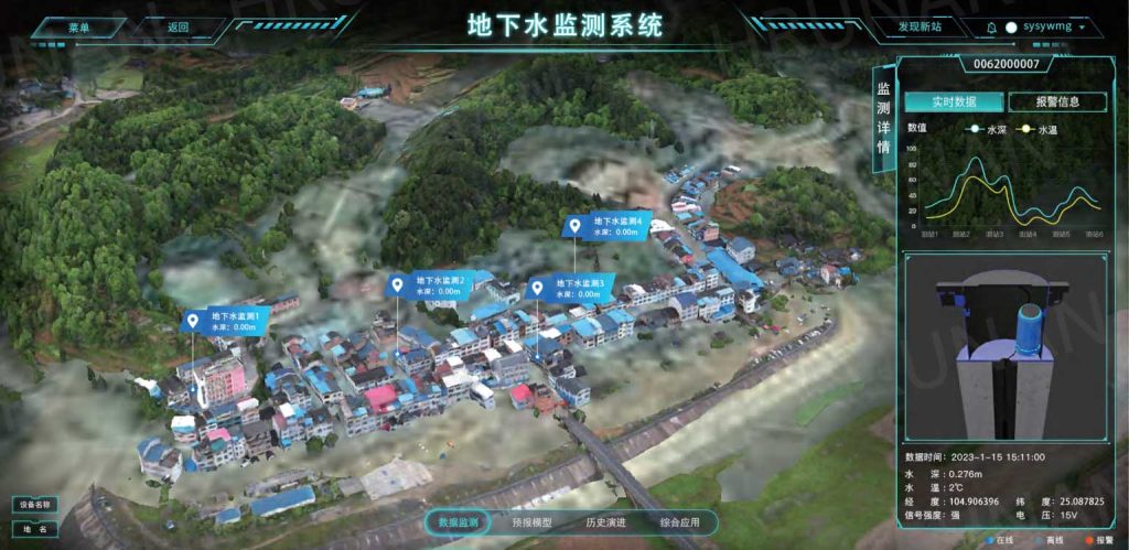
Groundwater Monitoring and Management Platform
The platform remotely monitors groundwater level data in real time, visual monitoring of data, abnormal alarms and early warnings.
The Groundwater Monitoring and Management Platform enables real-time monitoring of water usage across industrial, domestic, ecological, and agricultural sectors, as well as surface and groundwater levels and river and lake water quality. By analyzing the spatial and temporal distribution of water demand, it facilitates the unified allocation and scheduling of water resources.
The HRUNAN Comprehensive Water Conservancy Management Platform integrates various subsystems,including the Smart Irrigation Management System, Reservoir and Dam Safety Management System, Ecological Flow Management System, Flood Forecasting System, Reservoir Water and Rainfall Monitoring System,Gate and Pump Control System, Urban Flood Prevention System, and Water Quality Monitoring. Through precise GIS mapping and intuitive heatmaps, it displays rainfall information visually. The platform supports real-time alerts for equipment status and rainfall conditions, with notifications promptly sent via SMS. It also collects real-time video and image data from the field, offering users a clear visual representation. Graphical,scenario-based monitoring of gate operations is available, along with timely analysis of trends for key factors like rainfall, water levels, and flow, helping users respond effectively.
Built on advanced technology architecture, the platform provides services such as data collection, GIS positioning, hydrological early warnings, video and image monitoring, mobile internet applications, app and SMS-based weather alerts, and large-screen displays. The system follows a productized, modular design approach, enabling the rapid creation of solutions tailored to different use cases. Modules can be deployed and operated independently or managed in a unified platform for streamlined control.
The Groundwater Monitoring and Management Platform enables real-time monitoring of water usage across industrial, domestic, ecological, and agricultural sectors, as well as surface and groundwater levels and river and lake water quality. By analyzing the spatial and temporal distribution of water demand, it facilitates the unified allocation and scheduling of water resources.
The platform remotely monitors groundwater level data in real time, visual monitoring of data, abnormal alarms and early warnings.
System Advantages
◆Displays the status of equipment on a GIS map, showing real-time data and alarm notifications.
◆Monitors and displays groundwater levels and quality, along with graphical trends of the data.
◆Monitors and provides alarms for real-time operational conditions such as pressure, temperature, current, andsignal at the field terminals, and tracks the statistics of inspections and maintenance work orders for on-site.
◆equipment. Displays alarms for on-site operational data when waterlevels or water quality exceed the defined thresholds.


